
Òbrôzk:Nseamap.gif
Felëje wikszô miara.
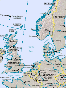
Nseamap.gif (280 × 374 pikslów, miara lopka: 43 KB, ôrt MIME: image/gif)
Map of North Sea, from the US Department of Energy: http://eia.doe.gov/emeu/cabs/northsea.html
Русский: Северное море
| This image is a work of a United States Department of Energy (or predecessor organization) employee, taken or made as part of that person's official duties. As a work of the U.S. federal government, the image is in the public domain.
Please note that national laboratories operate under varying licences and some are not free. Check the site policies of any national lab before crediting it with this tag.
|

|
Historëjô lopka
Klëkni na datum/czas, abë òbaczëc jak wëzdrzôł lopk w tim czasu.
| Datum/Czas | Miniatura | Miara | Brëkòwnik | Òpisënk | |
|---|---|---|---|---|---|
| aktualny | 16:20, 26 str 2005 | | 280 × 374 (43 KB) | Ivan~commonswiki | Map of North Sea, from the en:US Department of Energy: [http://eia.doe.gov/emeu/cabs/northsea.html http://eia.doe.gov/emeu/cabs/northsea.html] {{PD-USGov}} |
Lënczi do lopka
Hewò są starnë, jaczé òdwòłëją sã do negò lopka:
Globalné wëzwëskanié lopka
Nene lopk je téż brëkòwnóny w jinnych ùdbach Wiki:
- Wëzwëskanié w als.wikipedia.org
- Wëzwëskanié w am.wikipedia.org
- Wëzwëskanié w ast.wikipedia.org
- Wëzwëskanié w as.wikipedia.org
- Wëzwëskanié w ban.wikipedia.org
- Wëzwëskanié w ba.wikipedia.org
- Wëzwëskanié w be-tarask.wikipedia.org
- Wëzwëskanié w cv.wikipedia.org
- Wëzwëskanié w da.wikipedia.org
- Wëzwëskanié w de.wiktionary.org
- Wëzwëskanié w diq.wikipedia.org
- Wëzwëskanié w en.wikipedia.org
- Wëzwëskanié w eo.wikipedia.org
- Wëzwëskanié w gl.wikipedia.org
- Wëzwëskanié w he.wikipedia.org
- Wëzwëskanié w hif.wikipedia.org
- Wëzwëskanié w hr.wikipedia.org
- Wëzwëskanié w hu.wiktionary.org
- Wëzwëskanié w id.wikipedia.org
- Wëzwëskanié w is.wikipedia.org
- Wëzwëskanié w it.wikipedia.org
- Wëzwëskanié w it.wikibooks.org
- Wëzwëskanié w ja.wikipedia.org
- Wëzwëskanié w jv.wikipedia.org
- Wëzwëskanié w ka.wikipedia.org
- Wëzwëskanié w kw.wikipedia.org
- Wëzwëskanié w lij.wikipedia.org
- Wëzwëskanié w lt.wikipedia.org
- Wëzwëskanié w ml.wikipedia.org
- Wëzwëskanié w mn.wikipedia.org
- Wëzwëskanié w mwl.wikipedia.org
- Wëzwëskanié w nn.wikipedia.org
- Wëzwëskanié w olo.wikipedia.org
- Wëzwëskanié w pl.wiktionary.org
- Wëzwëskanié w pt.wikipedia.org
- Wëzwëskanié w roa-tara.wikipedia.org
- Wëzwëskanié w ru.wikipedia.org
- Wëzwëskanié w ru.wiktionary.org
- Wëzwëskanié w sah.wikipedia.org
- Wëzwëskanié w sco.wikipedia.org
- Wëzwëskanié w simple.wikipedia.org
Pòkôżë lëstã glonal;negò brëkwaniô negò lopka.