
Òbrôzk:Madagascar - Location Map (2013) - MDG - UNOCHA.svg

Pierwòtny lopk (Lopk SVG, nominalno 250 × 250 pikslów, miara lopka: 321 KB)
_-_MDG_-_UNOCHA.svg)
Òpisënk
| Òpisënk |
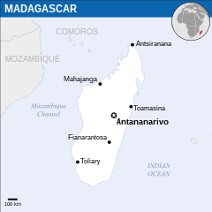
English: Locator map of Madagascar. |
| Datum | |
| Zdrój |
English: Madagascar Locator Map (ReliefWeb) |
| Aùtor | |
| SVG rozwój |
Licencëjô
- Mòżesz:
- dzélëc sã – kòpirowac, rozprowôdzac, ódtwarzac ùsôdztwò
- zmieniwac – ùsôdzac zanôléżné ùsôdztwa
- Na nôslédnych warunkach:
- ùznanié ùsôdztwa – Ùsôdztwò je nót nacéchòwac na ôrt òpisóny przez ùsôdzcã abò licencjodawcã.
 This map is part of a collection of 216 free country maps, created by the UN Office for the Coordination of Humanitarian Affairs (OCHA), to be used in print, web or broadcast products.
The ReliefWeb Location Maps released here are maps that highlight a country, its capital, major populated places and the surrounding regions. Attribution Requirements
Using the map without modifications: ensure that the sources and the disclaimer are below the map. Credit as follows: "Credit: OCHA". For use with alteration: remove the OCHA logo and disclaimer following any modification to the map, but keep the data sources as mentioned below the map. Credit the modified map as follows: "Based on OCHA map". You are responsible for the content of your map. We are keen to receive your feedback and hear how you used OCHA's maps. We would be grateful if you would notify us by e-mail and share your work with us. UN Disclaimer
The designations employed and the presentation of material of this map do not imply the expression of any opinion whatsoever on the part of the Secretariat of the United Nations concerning the legal status of any country, territory, city or area or of its authorities or concerning the delimitation of its frontiers or boundaries. |

|
Textual information (e.g. timestamp) once visible in the image itself has been moved into the image metadata and/or image description page. This makes the image easier to reuse and more language-neutral, and makes the text easier to process and search for. Commons discourages placing visible textual information in images. All licenses accepted on Commons permit this type of modification as a derivative work.
If attribution information were removed and the image is not public domain, replace this tag with {{Attribution metadata from licensed image}}.
|
Historëjô lopka
Klëkni na datum/czas, abë òbaczëc jak wëzdrzôł lopk w tim czasu.
| Datum/Czas | Miniatura | Miara | Brëkòwnik | Òpisënk | |
|---|---|---|---|---|---|
| aktualny | 12:38, 20 gro 2023 | | 250 × 250 (321 KB) | Illchy | File uploaded using svgtranslate tool (https://svgtranslate.toolforge.org/). Added translation for id. |
| 21:34, 30 gòd 2022 |  | 250 × 250 (320 KB) | Wikijahnn | File uploaded using svgtranslate tool (https://svgtranslate.toolforge.org/). Added translation for ca. | |
| 10:59, 20 str 2016 |  | 250 × 250 (319 KB) | Wereldburger758 | Resized page to drawing. Removal watermark. Validation of image. | |
| 01:49, 8 môj 2014 |  | 254 × 254 (339 KB) | UN OCHA maps bot | == {{int:filedesc}} == {{Information |description={{en|1=Locator map of Madagascar.}} |date=2013 |source={{en|1=[http://reliefweb.int/map/madagascar/madagascar-location-map-2013 Madagascar Locator Map (ReliefWeb)]}} |author={{en|1=[... |
Lënczi do lopka
Hewò są starnë, jaczé òdwòłëją sã do negò lopka:
Globalné wëzwëskanié lopka
Nene lopk je téż brëkòwnóny w jinnych ùdbach Wiki:
- Wëzwëskanié w arz.wikipedia.org
- Wëzwëskanié w as.wikipedia.org
- Wëzwëskanié w ca.wikipedia.org
- Wëzwëskanié w en.wikipedia.org
- Wëzwëskanié w fr.wikipedia.org
- Wëzwëskanié w he.wikipedia.org
- Wëzwëskanié w id.wikipedia.org
- Wëzwëskanié w it.wikipedia.org
- Wëzwëskanié w mdf.wikipedia.org
- Wëzwëskanié w pl.wikipedia.org
- Wëzwëskanié w sd.wikipedia.org
- Wëzwëskanié w www.wikidata.org
_-_MDG_-_UNOCHA.svg)